It has been awhile since I have done a post. I have been doing just day hikes for exercise and fun since getting back from the second Tahoe Rim attempt. I really have been through almost every hike in Missouri, some multiple times, so I have been looking for more unusual hikes to more obscure places.
Vicky and I did the Vilander Bluff Overlook hike a few weeks ago that I posted just to Facebook. It is here
This was simply, a small, couple hundred yard, detour off the main trail to a very scenic overlook of the Meramec River.
I have been looking for more like this but a bit longer. I ran across the Green's cave route, which is described as a bushwhack in the 60 hikes within 60 miles of St Louis by Steve Henry. I have hiked all the other trails in his book. This is the 3rd addition from 2010. I imagine that in 2010 this would have been a real bushwhack having seen very little use even though Green's Cave is a very beautiful spot it is normally only accessible if you float the river.
There are two ways to reach the Cave, both bushwhacks from either Millers Hollow, the route I choose because it was the hardest, and Hamilton Hollow coming from the same distance in the opposite direction. Both are listed as about 5 miles round trip.
Since it is 2020 I wondered if anyone had made a GPS file for the route yet. Doing a Google Search I found one on AllTrails done by Rick Inhat or Rick's own page here
Be aware the two routes differ. the GPX track by Rick is different than the description in Steve Henry's book. The GPX track is a bit "wilder" than following the description in the book, but both will require you are comfortable being lost! Lost in the sense that you know where you are but you need to be able to read the map/terrain and understand your directions in the woods.
The route from this side starts at what is now a sketchy pull out along Sleepy Hollow Rd just over the Meramec River bridge on Highway 185. It is now just a muddy pull off, a few hundred feet beyond an abandoned silo, that might hold two pickup trucks. I would not recommend parking here for longer than you plan to hike this out and back.
Not much room to park
The book describes you needing to step over a berm in order to find the trail. The berm is long since eroded away and you can see a faint trail leaving the area you parked. As I eluded too above the path my have once been a true bushwhack the whole way, but many hundreds of people have come this way now and the path is visible here
However in this first 300 yards take care with what you have on. This is a flood plain for the creek and the only thing that grows here are thorny bushes and spindly trees that will tear at everything you are wearing ! Follow the most obvious path along the creek until you come to a big berm that blocks your way and you will see two very old gate posts, still with some hardware. This is your place to cross the creek.Once across the creek the path becomes even easier to see and you follow it for another 150 yards and it will make a sharp left away from the creek, just follow along.
For the next half a mile the trail is super easy to follow, as good as any marked trail. You will pass by a great looking set of cliffs on your left and notice that the old road you are on is actually raised.
With the cliffs on your left you will pass by a small spring fed pond on your right. You can go around the pond on either side but the left side is the drier option. Spring fed pond
At the end of that half mile and the end of the cliff bands you will reach Beaver Spring Lake. This is actually man-made and would have been the foundation of a dam that would have buried this entire area under water including Green's cave. Over time this has filled with pretty green/blue water.Another view across the pond to the end of the cliffs on the other side. As an alternate you could have walked directly along the cliffs instead of the trail and ended up in the same spot at the end of the lake.
Frost Flower- I started the walk at 28 degrees F and ended it at 31, 3.5 hours later, so the day stayed chilly. It tried to snow and couple of times, but it was just moments of sleety rain.
At the end of the lake you continue on for another .3 miles you will come to a junction in the grass that looks like you could go off in 3 different directions, Straight ahead and right or left. There is actually a cairn marker in the grass and a few strips of surveyors pink tape in the trees to your left. I chose to go left and found a good old road that went straight up hill toward the highest point in the area. I followed it for about .2 miles and stopped as it didn't seem to be going anywhere exciting and certainly not in the direction I wanted to go.
Back down to the cairn I went passing an old fire ring just off the road. I continued on straight, coming from the lake, on the most obvious route. In fact if I had copied the correct pages from the book this is where Rick Inhats GPS track goes off to the left.
Here is what that direction looks like (not much there except some cedar trees and a dead end)
I continued on straight and appeared to dead end at what was an old water cistern. This turns out to be the path to the old quarry that was making rock for the dam. Also some where in here is the right hand turn that Steve Henry wants you to take. Both Steve and Rick have you crossing the old creek on your right around here. I didn't continue on to the quarry as I was now in doubt of finding anymore easy roads to walk.In Fact here is where all visible signs of a path vanish.
I never assumed I would have this much clear access but once you have it, you miss it when it is gone. I crisscrossed my way across the creek and searched a bit for any remnants of old roads, but found none. I studied my map and GPS and saw that the GPS track eventually ends up on a ridge about 400 feet above me. So I set a bearing and just went straight up hill until my position was the same as the GPS track and viola` I was standing an easy to see old road track. This was actually easy to follow, except for a few down trees and brush, up the hill and along the ridge
Now from where I gained the old road bed to the animal pond is another .3 miles of easy walking and great scenery as you climb.
Here is the second place my two sources differ. the GPS track from Rick takes me on a less obvious old road to my right and down steeply to an old Farm house foundation. The guide book from Steve would have taken me up and around a bit higher before dropping down to the cliffs above the cave.
So I went down. Definitely a more washed out road but the Farmhouse is easy to see on your left in a couple hundred yards and the road, while looking more like a washed out creek keeps dropping away in front of the farmhouse toward the river and cave location.Steve, in his book points out this is not the way and bushwhacking will ensue! If only I would have made copies of the correct pages!
Old Farmhouse foundation (above) and outhouse (below)
So this old road does take you all the way to the cliff face down by the river, pretty straight forward and you excited to see what looks like, what is left, of a man made bridge. You are in the wrong place! Do not go down this way, as I did, you will have a very painful scramble along the river bed for about .2 miles. This is mud and thorns and a real mess of tangled trees. Down at the river it is pretty but then hiking down to the cave is a pain from here. If you go this way just stay up on the cliff face and make your way down to just above the cave's location. The bushwhacking will be much easier!
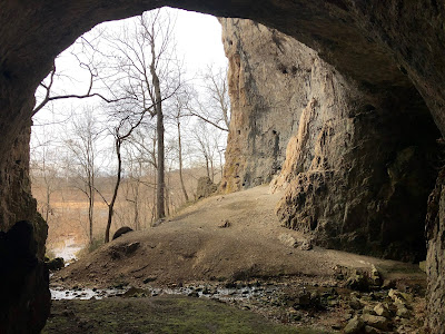
I did make my way down the bank to the cave entrance and it is spectacular. The cave entrance is huge. This is one of the few caves with no bars to protect the bats from White Nose Syndrome (WNS), although it did have a sign saying the cave is closed and to stay out for their safety. I stayed at just the entrance and alcove and did not venture back into the cave as requested.
Missouri is known as the cave state and this is perfect example of extraordinary caves we have. I am sure this cave goes back VERY far! There are 43 caves in this park and Green's has the biggest entrance of any cave east of the Mississippi. It is also the prime reason the dam was not built here, as water, as you can see running out of the cave, tends to steal water from dams.
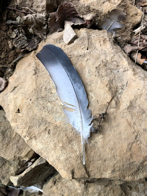
The cave entrance is 91 feet high by 108 feet wide Besides bats the cave is home to A LOT of pigeons
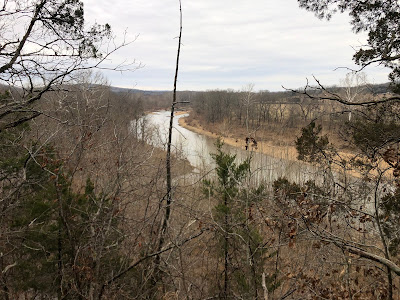
Leaving the cave, I took the "official" way up. It is clearly the way up to the cliff edge and while steep, much easier than the river route I took. On top of the bluff you can get great views up and down the Meramec River
Looking down the "official" path
Since I had not come down to the cave my own way, I tried to find a better path back, the subtle path leads first to some historic trash. It is difficult to believe that cars used to get this far back in the woods. Most of this rubbish looked decades old.
Once I hit the animal pond again, after coming back by the old homestead, I never did find the Steve Henry's path around the head of Miller's hollow (next trip), I continued back down hill and continued on the path that I missed by coming straight up hill. (Below) you can see that the old road sometimes is washed completely away and you have to search a bit for it.
I did find the other old farmstead and behind it a path to the river and a good swimming hole, in warmer weather, but after here the old road and any sign of trail disappears again and had to crisscross my way in the direction I knew to go.
I did manage to come back out right at the correct spot marked by the cairn and flagging tape, not quit following the GPS track or the book instructions, but that was the point of today anyway was to figure out where to go and how to get there. The book says it is approximately 5 miles round trip. I had it at 7.33 miles in 3hr and 25min. A great time was had !
In a week or so I might try to find the cave from the opposite end.
A final word about this route and area. Do NOT attempt this route in the summer. The tall grass and dense bushwhacking would be a haven for ticks and chiggers and you would simply be eaten by things you never got to see! Do not do this route if you have any fear of getting lost and have only walked on marked park trails with blazes that are maintained. While it is short in distance, in the winter time with the leaves off, everything in the woods looks the same in every direction and you need to know how to read the lay of the land and a map or GPS. Please do not go into caves that are signed closed. if you do venture into a cave you need to bring 3 light sources and extra batteries and/or a charging device.


