Don't go, Just don't do it. This blog is riddled with this warning, but somehow each year I manage to do it anyway. That 'it' is to go hiking in Missouri in the summertime. While technically it is not the summer yet, the summer heat got turned on last week and it appears to be staying.
This weekend was planned out a month or so ago by Cory, Joe and myself. Cory wanted "needed" a few nights out in the woods (don't we all) so it was decided we do a section of the OT that Cory has not done. The Middle Fork section. Relatively flat, a good amount of reliable water and about 25 miles total.
We planned to stage a car at Brushy Creek Lodge at the southern end of this section and start from the North end at the Hwy 32/DD trailhead. A few days before the start, Joe had to pull out with the continuing issues he is having with his knee. (he let us know that there is a new knee in his near future). Now a duo, I parked at Brushy Creek Lodge and Cory came and picked me up Friday morning around 9:30 am.
Our planned weekend- Middle Fork Section of the Ozark Trail
Cory dropped his jeep off at the trailhead. As anticipated there was not any other vehicles at the trailhead. Who would come out with temperatures close to 90 F?
I signed the register (hundreds of ants in the register box) and we were off, right at 10 am.
There is a very nice plaque, at both ends of this section, commemorating John Roth, an early proponent and tireless volunteer of the Ozark Trail
We came across these two turtles almost immediately. The one of the right was flipped over on its back. Either they were in a fight and there was a clear loser or they were making turtle "whoopie" and got a bit carried away. I set the turtle right side up again and left them to sort it out.
Lots of wild flowers along this section.
When the trail passes through hardwoods or pines it is in nice shape
This fawn was not so fortunate. We found pieces of him on the trail, likely a coyote.
A couple hours in we came to a creek at mile marker 7 (mm7). It was time for lunch.
It was hot but manageable today. There was some breeze and the bugs were not too bad.
Lots of good water here today.
In another mile you reach Wolf Pen "falls". Not sure why this gets the falls designation but there is a bit of a pour off over some rocks... 😂
The trail is good enough in the first section to be able to keep your head up and look around, so it was fortunate that I spotted this guy before I stepped right on him. This is about a 4 foot black snake, non-venomous and very useful, sunning himself on the trail. He seemed unconcerned with us and moved off the trail after a minute or two.
A bit too early for the blackberries growing along the trail
nice geode
Lots of creeks and they all had some water, so dipping your hat or getting water today is not a problem.
The trail is almost fully shaded now and that helped with the full heat of the direct sun.
at mm10
This spot is marked on the OT map as 'small pool' but that does not do it justice, it is the best swimming hole I have seen. Just after the spill off there is a 2-3 foot deep pool with a gravel bottom. A perfect place for a soak in the heat.
Our destination for today was Henderson Creek at mm10.5. It seemed the best way to break up the two days. 10.5 miles off the couch, get to camp early and give Cory that much needed hammock time! It has plenty of water and a nice campsite.
We made it here by 3 pm, so a little mid afternoon nap was in order. The convective cooling under the hammock was nice after a sweaty day.
Cory wore shorts, so a tick check was needed before hammock time.
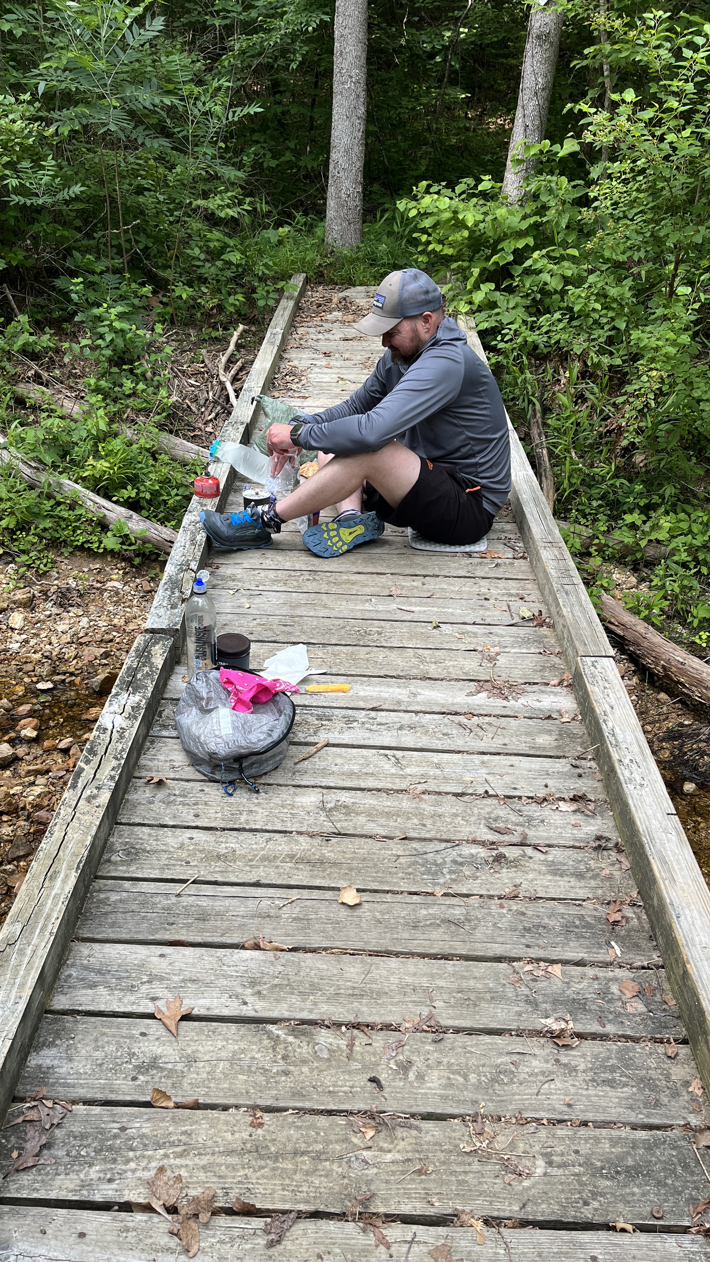
Around 6 pm it was time for some food and sitting on the bridge for dinner seemed the best spot. A little trouble with Cory's stove. The canister he was using was 5+ years old and the gas was not cooperating in coming out of the canister. He sorted out a method for getting it going that you will see shortly.
Just before it became dark, we had a deer "huff" at us several times from the tree line. We were perhaps in its way to the creek.
Hiking with a pack doesn't need to be completely without some civility. Cory brought his appropriately small pour over set up and we had freshly ground coffee for breakfast.
But first, I am sure you are wondering about the stove situation. Well the gas, being old, was not coming out in the correct mixture when it was in its normal upright position. We needed to get a bit of the liquid to get out to start things going.
DO NOT TRY THIS AT HOME, WE ARE TRAINED PROFESSIONALS. 😬
All packed up and ready to go. We are out on the trail by 8 am and the sun is just hitting this campsite. We left no trace at all and even managed to pick up some micro trash. We can already tell it is going to be hot and buggy today.
When we got up the hill to Forest Road 2367, the trail was blocked off with red tape. No other sign or posting. I figured it might have been left behind from the prescribed burn that was in this area a month or so ago. I will send a note to the OT and let them know it is here. We proceeded, better to ask for forgiveness than permission! 😀
This is the beginning of the Barton Fen area. The term “fen” is an Old English word that historically referred to lowland marshes, swamps, and bogs. Today, the term is used to more specifically refer to a particular type of wetland. Fens are characterized by a nearly constant supply of cold groundwater.
Barton Fen is home to the Hine's Emerald Dragonfly
internet photo
Only foot travel is allowed in the Fen. Horses and bikers use a bypass to the sensitive area.
A casualty of the winter or a predator
The Fen was a bit overgrown!
Walking along the cliff band next to Neal's Creek in the Fen
I was walking along the trail a bit in front of Cory and I saw a good sized raccoon (trash panda) run up the trail and into the woods. A moment later Cory called to me to come back and look up. There were 4 baby raccoons up a couple of trees being quit still. Mom had diverted my attention away from the babies that had climbed the tree for safety and I did not see them right above me.
photo by Cory
photo by Cory
A nice fern section
The day progressed along. The trail was undulating but mostly graded for horses and bikes so quite mild. It did get hot, very hot.
Lunch around noon was at Little Creek mm18
We ate and made sure to have enough water to reach the end, in about 6 miles, as the next water source is Strother Creek. It is pretty but it is directly down stream from a lead tailing pool and the water is considered not safe to drink. I did dunk my hat in to cool off, so hopefully I won't start to glow in the dark!
Cory crossing Strother Creek. No soaking here.
Not many pictures from here to the end. Just little ups and downs and lots of sweat. I did scare a fawn out of the grass that was no bigger than a dog and Cory saw another family of raccoons.
A mile from the end of this section is the other John Roth commemorative plaque.
That's it. We arrived at the end, the Hwy J Trailhead. We were done by 3:30 pm. We had planned to camp here tonight and then hike 2.5 miles of the Karkaghne section Sunday morning back to Brushy Creek Lodge, but it was early and HOT. In addition, the weather report was for a storm to start around 4 am and last most of the morning hours. We would have to walk out in the rain in the morning.
Instead we decided to hoof it out on the road back to my truck at Brushy Creek Lodge. The bad part is that it was 3 miles of road walking... brutal. Fortunately, we were offered a ride by a nice local guy in his 4 wheeler. He gave us a lift more than half way back to the lodge and saved us the pounding on our feet. Great trail magic to end the hike.
Since we were done, it just made sense to get a burger at the Bixby General Store
I asked for the biggest cheeseburger he could make!
Yum!
Animal sightings: Deer (alive and deceased), snake, raccoons, turtles, birds, fish, No other hikers, horses or bike riders.
Stats:
Friday
Day 2
Saturday
A bit more hills on Day 2
I ended up with just 4 chigger bites on my left leg, but no ticks.
Thanks again Cory, We missed you Joe.
Epilogue:
My meme post, in the Ozark Trail Section Hikers and Backpackers (OTSHAB) group was banned by Facebook for hate speech and inciting violence. Obviously, the bots at Facebook don't have access to a dictionary, don't consider the relevance of the post, in the group and have dirty minds!😡