Green's Cave via the Sleepy Hollow Bushwhack

It has been awhile since I have done a post. I have been doing just day hikes for exercise and fun since getting back from the second Tahoe Rim attempt. I really have been through almost every hike in Missouri, some multiple times, so I have been looking for more unusual hikes to more obscure places.

Vicky and I did the Vilander Bluff Overlook hike a few weeks ago that I posted just to Facebook. It is here  

This was simply, a small, couple hundred yard, detour off the main trail to a very scenic overlook of the Meramec River. 

I have been looking for more like this but a bit longer. I ran across the Green's cave route, which is described as a bushwhack in the 60 hikes within 60 miles of St Louis  by Steve Henry. I have hiked all the other trails in his book. This is the 3rd addition from 2010. I imagine that in 2010 this would have been a real bushwhack having seen very little use even though Green's Cave is a very beautiful spot it is normally only accessible if you float the river. 

There are two ways to reach the Cave, both bushwhacks from either  Millers Hollow, the route I choose because it was the hardest, and Hamilton Hollow coming from the same distance in the opposite direction. Both are listed as about 5 miles round trip. 

Since it is 2020 I wondered if anyone had made a GPS file for the route yet. Doing a Google Search I found one on AllTrails done by Rick Inhat or Rick's own page here

Be aware the two routes differ. the GPX track by Rick is different than the description in Steve Henry's book. The GPX track is a bit "wilder" than following the description in the book, but both will require you are comfortable being lost! Lost in the sense that you know where you are but you need to be able to read the map/terrain and understand your directions in the woods. 

The route from this side starts at what is now a sketchy pull out along Sleepy Hollow Rd just over the Meramec River bridge on Highway 185. It is now just a muddy pull off, a few hundred feet beyond an abandoned silo, that might hold two pickup trucks. I would not recommend parking here for longer than you plan to hike this out and back.

Not much room to park 


The book describes you needing to step over a berm in order to find the trail. The berm is long since eroded away and you can see a faint trail leaving the area you parked. 

As I eluded too above the path my have once been a true bushwhack the whole way, but many hundreds of people have come this way now and the path is visible here

However in this first 300 yards take care with what you have on. This is a flood plain for the creek and the only thing that grows here are thorny bushes and spindly trees that will tear at everything you are wearing ! 
Follow the most obvious path along the creek until you come to a big berm that blocks your way and you will see two very old gate posts, still with some hardware. This is your place to cross the creek.

Once across the creek the path becomes even easier to see and you follow it for another 150 yards and it will make a sharp left away from the creek, just follow along. 

For the next half a mile the trail is super easy to follow, as good as any marked trail. You will pass by a great looking set of cliffs on your left and notice that the old road you are on is actually raised.


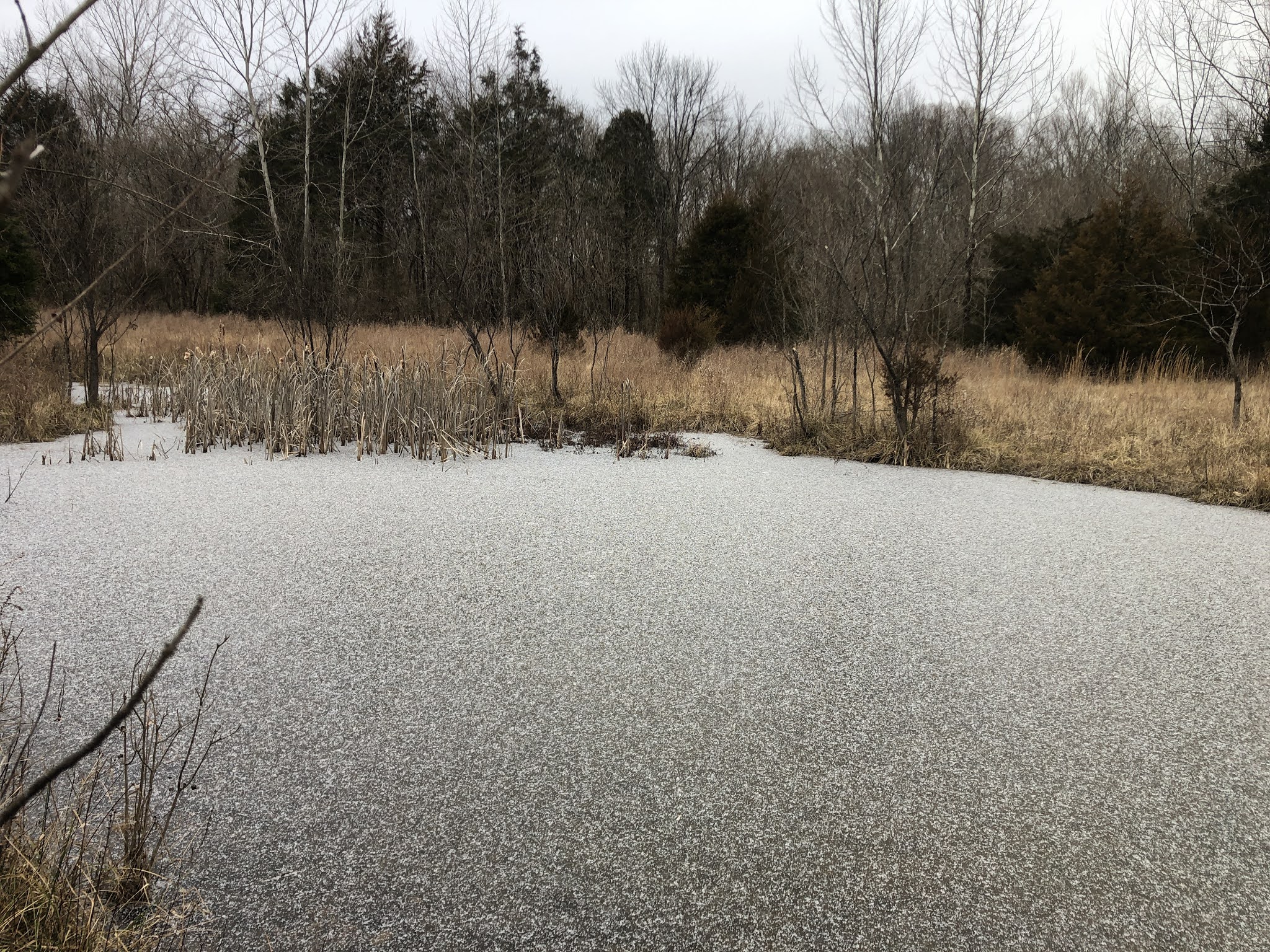
With the cliffs on your left you will pass by a small spring fed pond on your right. You can go around the pond on either side but the left side is the drier option. 

Spring fed pond 


At the end of that half mile and the end of the cliff bands you will reach Beaver Spring Lake. This is actually man-made and would have been the foundation of a dam that would have buried this entire area under water including Green's cave. Over time this has filled with pretty green/blue water.


Another view across the pond to the end of the cliffs on the other side. As an alternate you could have walked directly along the cliffs instead of the trail and ended up in the same spot at the end of the lake.

Frost Flower- I started the walk at 28 degrees F and ended it at 31, 3.5 hours later, so the day stayed chilly. It tried to snow and couple of times, but it was just moments of sleety rain. 


At the end of the lake you continue on for another .3 miles you will  come to a junction in the grass that looks like you could go off in 3 different directions, Straight ahead and right or left. There is actually a cairn marker in the grass and a few strips of surveyors pink tape in the trees to your left. I chose to go left and found a good old road that went straight up hill toward the highest point in the area. I followed it for about .2 miles and stopped as it didn't seem to be going anywhere exciting and certainly not in the direction I wanted to go. 
Back down to the cairn I went passing an old fire ring just off the road. I continued on straight, coming from the lake, on the most obvious route. In fact if I had copied the correct pages from the book this is where Rick Inhats GPS track goes off to the left. 


Here is what that direction looks like (not much there except some cedar trees and a dead end) 

I continued on straight and appeared to dead end at what was an old water cistern. This turns out to be the path to the old quarry that was making rock for the dam. Also some where in here is the right hand turn that Steve Henry wants you to take. Both Steve and Rick have you crossing the old creek on your right around here. I didn't continue on to the quarry as I was now in doubt of finding anymore easy roads to walk.

In Fact here is where all visible signs of a path vanish. 
I never assumed I would have this much clear access but once you have it, you miss it when it is gone. I crisscrossed my way across the creek and searched a bit for any remnants of old roads, but found none. I studied my map and GPS and saw that the GPS track eventually ends up on a ridge about 400 feet above me. So I set a bearing and just went straight up hill until my position was the same as the GPS track and viola` I was standing an easy to see old road track. This was actually easy to follow, except for a few down trees and brush, up the hill and along the ridge 

Now from where I gained the old road bed to the animal pond is another .3 miles of easy walking and great scenery as you climb. 
Here is the second place my two sources differ. the GPS track from Rick takes me on a less obvious old road to my right and down steeply to an old Farm house foundation. The guide book from Steve would have taken me up and around a bit higher before dropping down to the cliffs above the cave. 

So I went down. Definitely a more washed out road but the Farmhouse is easy to see on your left in a couple hundred yards and the road, while looking more like a washed out creek keeps dropping away in front of the farmhouse toward the river and cave location.
Steve, in his book points out this is not the way and bushwhacking will ensue! If only I would have made copies of the correct pages! 

Old Farmhouse foundation (above) and outhouse (below)

So this old road does take you all the way to the cliff face down by the river, pretty straight forward and you excited to see what looks like, what is left, of a man made bridge. You are in the wrong place! Do not go down this way, as I did, you will have a very painful scramble along the river bed for about .2 miles. This is mud and thorns and a real mess of tangled trees. 

Down at the river it is pretty but then hiking down to the cave is a pain from here. If you go this way just stay up on the cliff face and make your way down to just above the cave's location. The bushwhacking will be much easier! 

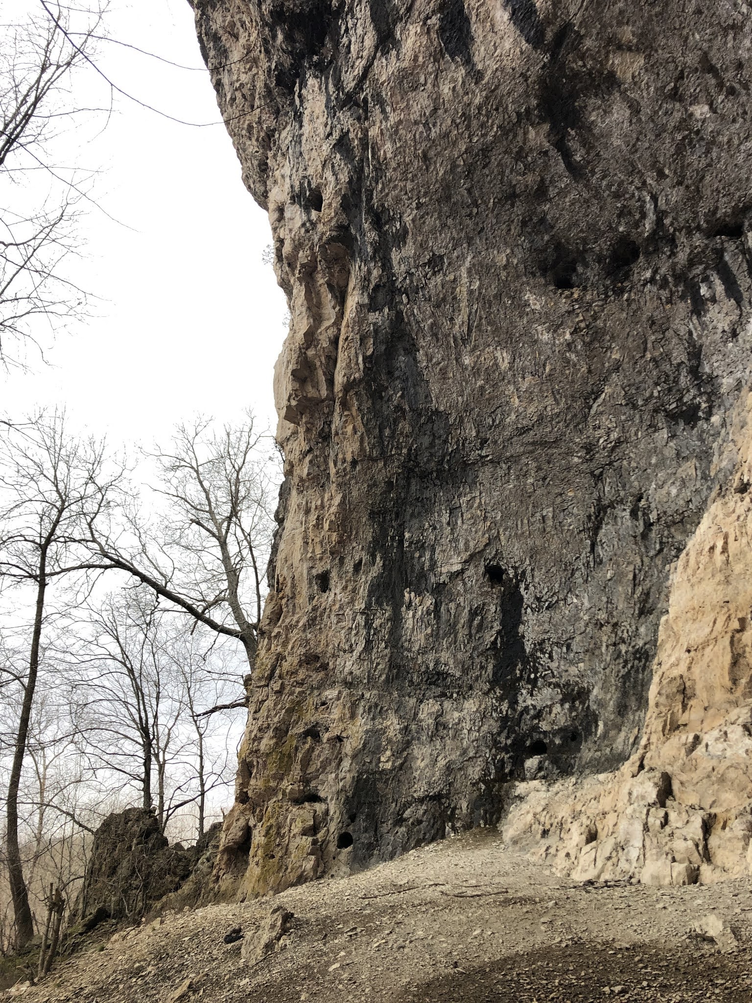
I did make my way down the bank to the cave entrance and it is spectacular. The cave entrance is huge. This is one of the few caves with no bars to protect the bats from White Nose Syndrome (WNS), although it did have a sign saying the cave is closed and to stay out for their safety. 

I stayed at just the entrance and alcove and did not venture back into the cave as requested. 


Missouri is known as the cave state and this is perfect example of extraordinary caves we have. I am sure this cave goes back VERY far! There are 43 caves in this park and Green's has the biggest entrance of any cave east of the Mississippi. It is also the prime reason the dam was not built here, as water, as you can see running out of the cave, tends to steal water from dams. 


The cave entrance is 91 feet high by 108 feet wide 


Besides bats the cave is home to A LOT of pigeons


Leaving the cave, I took the "official" way up. It is clearly the way up to the cliff edge and while steep, much easier than the river route I took. 

On top of the bluff you can get great views up and down the Meramec River 


Looking down the "official" path 


Since I had not come down to the cave my own way, I tried to find a better path back, the subtle path leads first to some historic trash. It is difficult to believe that cars used to get this far back in the woods. Most of this rubbish looked decades old. 

Once I hit the animal pond again, after coming back by the old homestead, I never did find the Steve Henry's path around the head of Miller's hollow (next trip), I continued back down hill and continued on the path that I missed by coming straight up hill.
(Below) you can see that the old road sometimes is washed completely away and you have to search a bit for it. 

I did find the other old farmstead and behind it a path to the river and a good swimming hole, in warmer weather, but after here the old road and any sign of trail disappears again and had to crisscross my way in the direction I knew to go. 


I did manage to come back out right at the correct spot marked by the cairn and flagging tape, not quit following the GPS track or the book instructions, but that was the point of today anyway was to figure out where to go and how to get there. The book says it is approximately 5 miles round trip. I had it at 7.33 miles in 3hr and 25min. A great time was had ! 

In a week or so I might try to find the cave from the opposite end.

A final word about this route and area. Do NOT attempt this route in the summer. The tall grass and dense bushwhacking would be a haven for ticks and chiggers and you would simply be eaten by things you never got to see! Do not do this route if you have any fear of getting lost and have only walked on marked park trails with blazes that are maintained. While it is short in distance, in the winter time with the leaves off, everything in the woods looks the same in every direction and you need to know how to read the lay of the land and a map or GPS. Please do not go into caves that are signed closed. if you do venture into a cave you need to bring 3 light sources and extra batteries and/or a charging device. 

Vilander Bluff Overlook Walk

Vicky and I went on a walk to find the Vilander Overlook in a small corner of Onondaga Cave State Park. It was a nice sunny day for November 


Vilander Overlook Post

Weekend with OTSHB Group at Johnson Shut In State Park

 A weekend with the Ozark Trail Section Hikers and Backpackers Group. Originally posted to Facebook 

Click Here

Tahoe Rim Trail- A Second Try- Aug 11-21 2020

Damn you 2020! This has not been a good year, obviously for many people, but particularly for me. Our trip to hike across Scotland (TGO Challenge) was cancelled for May, I needed a surgery in April, I was fired from my job, quite unexpectedly, at the end of June, all that was left was the planned Tahoe Hike in August that was the postponement of the hike from last September, when my father passed away, while I was half done with the trail.... see not a good last 12 months!

On top of that, as this TRT hike approached, Vicky and I were out for a couple of weeks in our RV, on a trip to South Dakota, when this trip had to be unexpectedly cut short, just as it started, as a re-occurrence of the same symptoms leading to my surgery appeared causing us to turn around and go home. This led to another surgery just 10 days before the TRT hike. I, however, was determined to go, despite still being in the early stages of recovery as this would have also effected "The" Bobbi Walters, who was coming along to try and finish the trail as well. 

The Beginning:

I had an early morning flight from St Louis thru Denver to Reno, the closest airport to the Lake Tahoe area. It was actually nice to get back on a plane again since I had not traveled for work since the beginning of the Covid lockdown at the beginning of April. 


Packing was easy as my pack base-weight was only 9 pounds and the forecast was very good weather for the next two weeks

When I arrived in Reno, Bobbi had already arrived the night before and we were picked up by my friend Elsye "Chardonnay" Walker, a triple crown hiker and a fellow ALDHA-West board member during my tenure with the Board. She lives in the Tahoe area and was very gracious to come pick us up in Reno and drive us the 90 miles to South Lake Tahoe! 


We arrived early in the afternoon and checked into the Beckett Hotel right in the heart of the South Lake Tahoe Heavenly Village area.

You get a great view of the Monument Peak and the Kingsbury South area, where we started out hike last year. 

Of course our first stop had to be BaseCamp Pizza and a fix of the Curry Chicken Pizza that you can get nowhere else and is fantastic

In addition hanging out on the sidewalk deck of California Burger Company and enjoying the late afternoon 


Hanging out in the deck chairs

C.B.C specializes in the best adult (alcohol) milk shakes (Shake, Rattle, and Roll is the best- see the recipe from our hike last year)


After that it was back to the room to repack one more time before starting early in the morning.
We were assisted by Suzanne, a Trail Angel (who is someone that helps hikers at no charge get to and from trail heads). She had picked us up last year from Echo Chalet and was nice enough to agree to take us back there this year. 

Day 1
12.14 miles
7'21" total time

A perfect day to start our hike at lower Echo Lake.


The houses along both lower and upper Echo lakes can only be reached by boat and some are just outrageous, including this one that reminds us of Hagrid's Hut in the Harry Potter movies

Looking at Upper and Lower (behind) Lakes as you rise above them on the trail 

Here you enter Desolation Wilderness, arguably the most rugged and beautiful section of the TRT.

We saw a huge amount of wildflowers last September, but here in August there was still plenty to look at along the trail 


You soon enter the "lakes" section. I have always thought this first lake (Lake Margery) was one of the prettiest with the mountains, Angora and Cathedral, in the background.

I love this wind swept tree
Aloha Lake is certainly the crown jewel of the lakes with Pyramid Peak, the tallest on the left. You can see Pyramid Peak from around the lake and the trail 


Heather Lake has a shore of nothing but Talus and some rather long shear drops from the trail 

Past Susie, where we camped last year, and up the hill is Gilmore Lake our first day stopping point.

Day 2
16.36 miles
8' 0" total time 

Day 2 dawned beautifully and since we had made it to Gilmore lake we were already part of the up the hill to Dick's Pass. After reaching Gilmore Lake last night I was in some pain from my recovery, but I did manage to eat dinner, However this morning the pain was a bit more and I needed a pain pill, which meant I didn't feel like eating any food this morning


Dick's Pass in the steepest climb on the TRT but the views just get better and better as you climb 

At the false pass (above) you look down directly on Dick's Lake, but it is still a bit more uphill to reach the actual pass (below)

Reaching the top you get some fantastic panoramic views from the flat stretch that lets you look in all directions. We stayed a while for a well deserved rest at the top and I tried to eat something but I still could not get down any calories.


Fortunately it is all down hill for the rest of the day (almost) so it was easy to come down from the pass (seen in the background below) we passed Dick's Lake, Fontanillis Lake (below) and the Upper and Middle Velma Lakes.
We took lunch here, but again I just rested and didn't eat.

Why do I feel like someone is watching me?

We debated on where to finish today with me feeling tired, but we finally decided to stay on schedule and make it to Richardson Lake. After passing middle Velma you go back up for about 2 miles, but then downhill 4 miles to camp. 

You pass out of Desolation Wilderness so our permits are complete (above) We arrived at Richardson not long before sundown and it was a beautiful sunset.
It had been a long day with lots of elevation gain and loss, Bobbi was able to make dinner, but as soon as the tent was up I was lying down. While I probably burned 6000 calories today, I probably only consumed about 300.  


Day 3
13.5 miles
6'58" total time

Another fine but hot day, we got up and out early to try and avoid some of the midday heat, this temperatures have been a bit higher than predicted for this elevation all week.


The first half of the day was nice and pretty straight forward. I still had issues with frequent wound care and lack of appetite but the walking was nice. We knew that after lunch we would have a significant climb around Barker Peak to the overlook of McKinney Bay (8256') and then way down only to go way up to Twin Peaks (8509').

Barker Peak from Barker Meadow (below)


We had a stop and long rest at Barker Pass around noon before tackling the toughest part of the day. 

I had a nap! 


After about a 90 minute siesta we started up the first hills.

The overlook to McKinney Bay (8256')

You drop way down into the next valley before going up again (you can see Twin Peaks in the background just left of center)

Better view of Twin Peaks


There is a series of 6 switch backs through scree and forest to get you back up to Twin Peaks


Finally arriving at the top and Twin Peaks 

We camped for the night, just up in the pines, right below the peaks where the PCT meets the TRT again. 

Day 4
13.15 miles
6'20" total time

Yesterday was a another beautiful day, but I just was still having issues, mostly with wound care, which I had to do multiple times during the day. In addition I just couldn't eat any dinner. I was not taking many pain pills, in fact I was biting them in half so only one full one during the entire day. To add insult to injury when I was breaking down the tent I discovered that some inconsiderate person had pooped on the ground and it was now all over parts of my tent!
GROSS!  


As soon we started our day we came to the marker that denotes the separation of the PCT (which we had been on since our start) and the true TRT that goes toward Tahoe City, which was our destination for today. 

The views today were very nice as most, if not all day, was downhill, except for a nasty bit of uphill just past Ward Creek parking area!
But it was just about at this beautiful spot in the day that I told Bobbi I was done and didn't feel like I could go on after Tahoe City. I was managing the pain and the wound care, but it was the lack of calories that was making it difficult to put in the days we needed to complete the trail in time.

Ward Creek bridge (above) this is usually the place to get water but it is not easy to reach in the steep ravine, there is actually a secret lovely, cold and clear spring just half a mile past here where the water tastes great coming right out of the ground! 


You spend a good deal of time on this dirt road heading out to the Ward Creek parking area (above) but after you have a very steep climb to Page Meadow, before making your final descent into Tahoe City.

Tahoe City is a lovely, small, expensive town right on the Lake and it was a welcome site in the early afternoon

We didn't even waste any time as we headed straight for the first restaurant with BIG burgers and cold cokes! We knew about the Tahoe Brew Haus from last year and even I was hungry for real food!

I could only eat less than half my food, but I took it with me and did eat it all by the end of the day. What they did have was homemade sodas. I had the rootbeer and the blackberry soda and it was sweet and cold and delicious. It was all the refills you wanted and they lost money on the amount of cold soda I drank! 

Bobbi had booked us into the Inn at the Boatworks. They had taken over the closed hotel we had seen last year in Tahoe City and have started to rejuvenate it. The Boatworks is a large commercial company that owns a shopping mall area and lots of property along the water in Tahoe City.

They have done a good job in getting some of the rooms redone and it was a fine place to stay albeit obscenely expensive for what you get, but that is the nature of Tahoe City. I was really only interested in the shower as I had not had any since leaving 4 days ago, as you can tell from my feet (below)


The rest of the day was really spent figuring out what to do next. This town seems to be a nexus for bad outcomes for me. We were only suppose to stay the night and I told Bobbi that I would support her continuing on without me if that is what she wanted to do. As it turned out her resupply box from home did not arrive via UPS (it was still in Sacramento, despite being sent more than a week earlier) and she was also harboring some aches and pains, she had been struggling toward the end of each day, so by the end of the night she decided she was done as well. 
I really didn't want to go home yet as I had not had a vacation in two years and with all our previous plans cancelled, I just didn't feel like going home yet, but we couldn't stay here as it was just too expensive. 

We managed to secure another night at the Boatworks in order to sort out what we would do.  That meant not having to hike in the morning but waking up and going to have breakfast at Rosie's, a must breakfast location in town! 
During an excellent breakfast (these are stock internet photos above and below) as I was too busy eating my pancakes, eggs and sausage to take pictures) we decided to go back to South Lake Tahoe, which was much cheaper and stay the remaining 4 days and just hike locally and in general relax and rest (which suited me just fine) 

It became site seeing day, mixed with movie watching and just laying around. However in the evening we did go for Mexican food at another spot in town the Blue Agave.

This time I did take pictures


A little whimsy around town

The next day our friend Elsye came again and was so kind to drive us back down to South Lake Tahoe. As it turned out this was fortuitous as unbeknownst to us the smoke from the wildfires in California were on their way and arrived in the Lake Tahoe area, hundreds of miles from their origin at those fires.

Arriving back in SLT the smoke had started to obscure all the views and in fact it would only be a matter of days before most new hikers were abandoning their starts and those are the trail were getting off, because of no views and the decreasing air quality, until as of posting this account weeks later, the entire trail is closed to to wild fire activity. 
We would not have been able to finish our hike with any quality as we would have been on the northern part of the trail which was most effected at this time.


Everyday the smoke got worse for the remainder of our trip

We did manage one more day hike, although cut short as Bobbi was having problems with the smoke, into Van Sickle State Park, which borders both Nevada and California.

We took a casino shuttle back to Reno, where we managed one more dinner (only my second sushi meal ever!) 

And then it was on a plane and back to home.

In the end I have to say a fairly disappointing adventure, although the scenery on the trail was beautiful and our timing with weather was great to get the first four days in. Tahoe has been a difficult area for me and one that I think I will now leave alone for good. Don't let me account put you off, this trail is well worth doing but the logistics to get to it, from anywhere except local, is difficult and expensive and the weather can be, (and has been for me) very challenging.
In fact, this trip solidified a decision that I have been wrestling with for many months now and that is my decision to effectively retire from long distance backpacking. For a variety of reasons I have not been getting the same enjoyment out of being out for multiple days as I once did and so it time to lay that down and think about what will again recharge my batteries moving forward.... 

Special thanks to "The" Bobbi Walters for being such a good sport. We have not been good at actually getting a hike done anywhere, but I appreciate the company! 


Support Our National Parks - Preserve - Protect - Enjoy