Hike around Garden Of The Gods Dec 20-21 2013


A Hammock Forums get together at Garden of the Gods Wilderness Area in Southern Illinois. I have never been to GOTG and was really looking forward to getting out there to see the unusual rock formations. The Hang was going to be well attended with 5 or 6 members coming.... Until life gets in the way...
In the end only Deutschland Sprott (Seth) and myself attended, but the area lived up to its reputation of some great scenery. It also provided one heck of a rain storm!


Indian Point trail is the first loop from the Backpackers parking lot and is about a mile and a half loop of some classic GOTG shaped rock and caves.

Panorama views of "false" Indian Point (directly below) and then Indian Point 

This trail and these spots would make a great group hang site for a Hammock Forums group hang


Deutschland Sprott (Seth)  who did all the organizing for the hike.

 Several caves along the loop that were quite large. you could spend the afternoon just exploring all the "ins and outs" of this loop section


 After that loop we decided to hike around the GOTG loops to the other rock features pointed out in the visitors guide.
A section of the River to River trail ( a 200+ mile trail in Southern Illinois that goes from the Mississippi River on the west to the Ohio River on the East) runs through the GOTG Wilderness area, so we took that for a mile or so.

The weather forecast called for rain all weekend 70% chance Friday, Saturday, Sunday. It held off during the day on Friday and the temperature was 64 degrees for Dec 20th!
The overcast skies gave everything a lovely "muted" color. the rocks were all covered in green with contrasted by the brown of the leaves.


 After following a trail that at the beginning was well marked and then not marked at all, we made our way successfully to our campsite by a very nice stream with a great overlook.
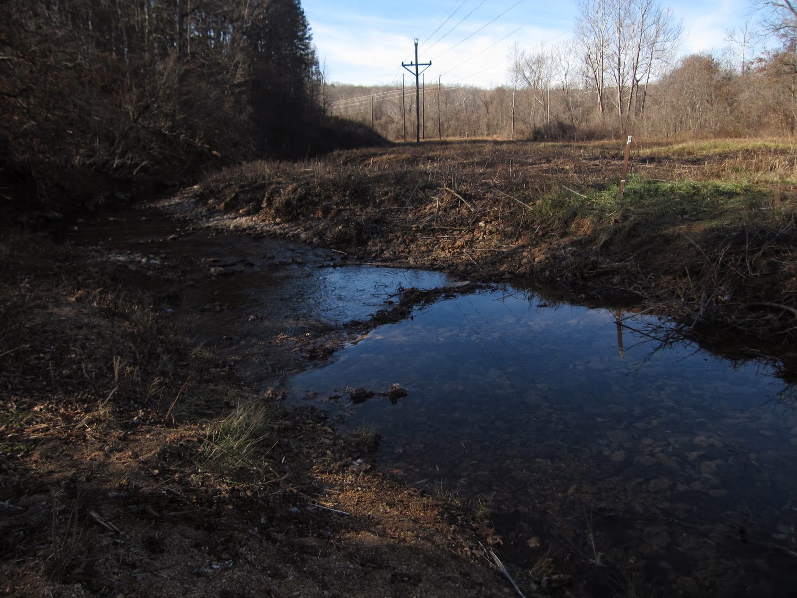
We nestled down in the trees

 Next to "Turtle Rock"
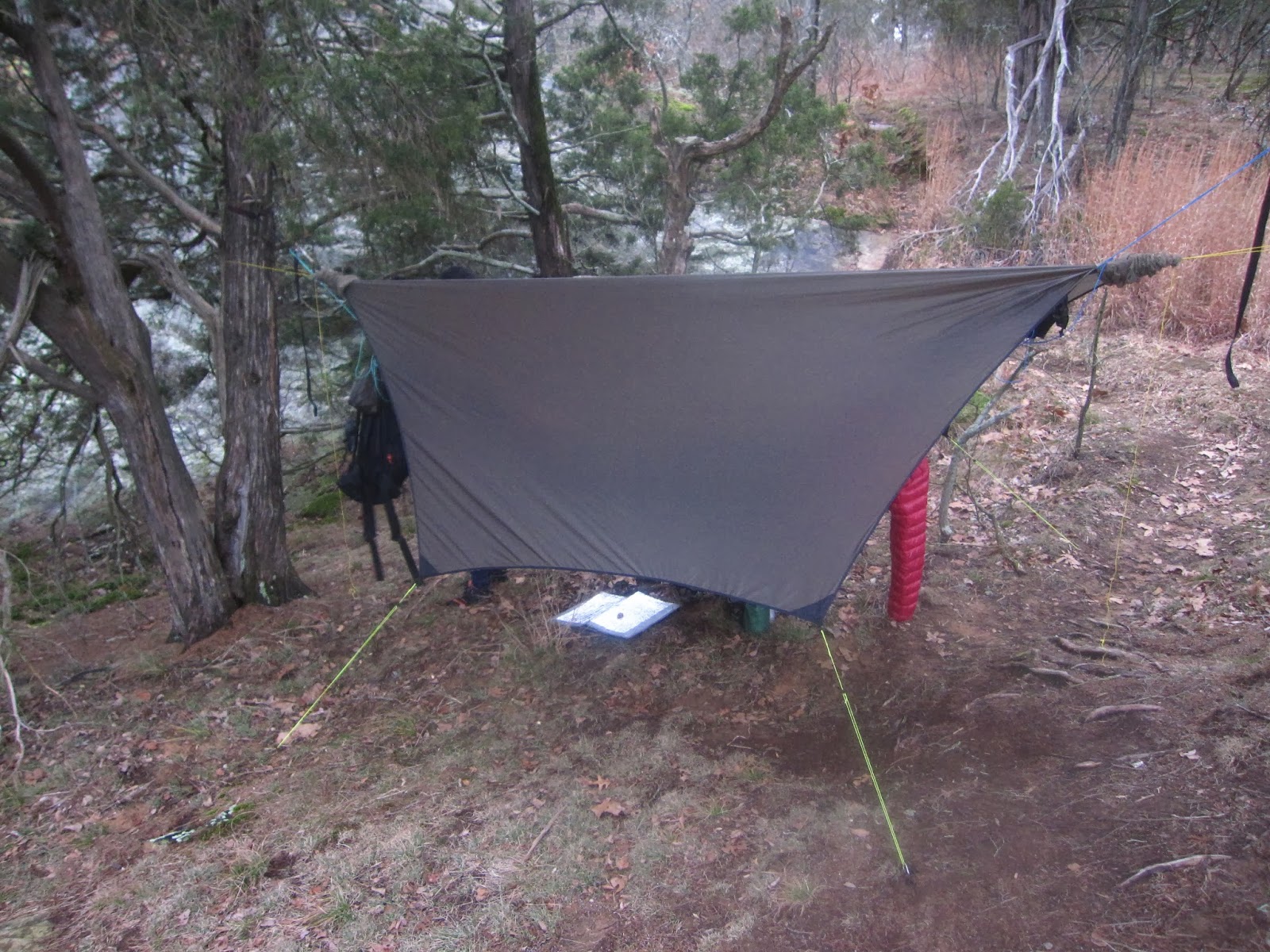
with a nice view into the creek bed and across to the ridge 

Dinner was relaxed and we chatted until dark (5:30 pm) !!


About 8 pm it started to rain! and I mean RAIN. the wind had died down, but it stormed all night and into the next morning, causing a river of mud and water to run down the hill above us and under my hammock set up. Seth had a little water issue at about 3 am that ruined his night sleep, but nothing serious. I managed to stay warm and dry until 6:30 am.
I heard later it was close to 7 inches of rain in that 12 hour period.

Packed up and heading out the short distance back to the car. With the forecast for more rain all day making viability low and the temperatures falling we decided it was enough. If we couldn't see the views we would come back another day- and we will, as this is an excellent area to explore.

Garden Of The Gods- Wilderness Area, Southern Illinois Area- just southeast of Herod Illinois.
5-6 miles hiked
Indian Point Trail
River to River Trail
Park Trail 001A

Video:  


More Videos Posted

A video from a previous one night hang on Bell Mountain in November. This was actually the week before the longer Ozark Trail hike. I didn't realize I had some good video footage especially of the morning sunrise.


Video of the three nights on the Berryman trail with "Kerflop" and "Hoot"

Part 1

Part 2


Ozark Trail Hike Berryman Campground to Hwy A (Bell Mountain) 39 miles November 13-15, 2013 Day 3 continued

Day 3- On My Own- Hwy DD parking area- Hwy A Trailhead 12 miles

After parting with the guys I looked at the map and decided to break the day up mentally into two parts, well three if you count the first 5.5 miles we all did together. I had 5.5 miles to Hwy 32 and then 6 miles to the finish. I knew the terrian would be much harder south of 32 so I decided to push myself in this section to make up some time.

I made it down to the split of the OT and the Council Bluffs trail ( past Nazarenko Spring)  in just 20 minutes


On top of the first rise 2.5 miles in 45 minutes
 the intersection of the split in the OT, south toward Bell Mountain or west toward the Middle Fork section. in 1 hour- 3 miles


Made it to Hwy 32 in 1'49" Kept up the 3 mph pace for the first 5.5 miles
 Crossing Hwy 32 into the older section of the OT is much harder. the trail seems to go straight up and down and doesn't contour as much. Hwy 32 is at 1460 feet and the streams are at around 500 feet. I would do this 4 times in the next 6 miles
 Panther Branch was good for 2 liters of water

More "turkey" fungus

 still some great views when you did top out on each ridge 
fortunately for me every valley had water except Big Spring just north of Hwy 32


old model A in the creek bed a Peter's Cave Hollow- I still missed seeing the caves- someday I will have to get back just to find them.
 As I came down the last ridge line I can see Bell Mountain across the valley from where I was standing


Done! 4'48" for 12 hard miles. Had the guys picked up in 30 more minutes and in 90 minutes we were eating in Boos Market and Diner in Potosi Mo having dinner....  I can recommend it highly.

Stay tuned for the video with me walking into a shooting range in the Hwy A parking lot.

Ozark Trail Hike Berryman Campground to Hwy A (Bell Mountain) 39 miles November 13-15, 2013 Day 3

Day 3- Trace Creek to Hwy DD Trailhead- with the group 5.5 miles
It was very windy and cold last night and I had the tarp pitched low to block some of the wind, but I had the hammock system "dialed in" and was actually sweating at certain points in the night and had to take cloths off to vent.
We got water from Trace creek again and started out about 8:15 am. we had some miles to do but the guys had not sleeped very well, waking up with a fever and various sore ligaments and feet issues. the discussion was the they would stop at Hwy DD ( Council Bluffs Lake Parking Lot) after 5.5 miles and I would hike on to the Hwy A trailhead, and additional 12 miles get Bob's car and come get them.

Eric on the left and Bob below still made good time in the morning even nursing some ailments


more small things


Wilderness boundry marker reminding everyone that ATV are not allowed. With hunting season approaching that is pretty much ignored in this area.


The Beech trees had dropped their yellower leaves and it made a nice contrast to the normal brown and reddish of the oak and maples.

We arrived at Hwy DD in just 2 hours, for 5.5 miles and after some discussion it was decided that Bob and Eric would hang out in the parking area and I would hike on. I dropped my food, except for some snacks and my cook kit and took off down the trail. It was 10:30 am.


Ozark Trail Hike Berryman Campground to Hwy A (Bell Mountain) 39 miles November 13-15, 2013 Day 2


 Day 2 - Ridge above Snapps Branch to Trace Creek area.  10 miles

The second day dawned as good as the first and even a little warmer.It was great view of the surrounding hills

 We had climbed to the ridge line to take advantage of the first rays of sun and not spend the night in the "Hollar" where it would be colder longer- we were right, we got the sun right away.

 Bob getting everything packed up and ready to move out.

another nice day to walk in the woods


After walking through the Hazel Creek campsite we came to Town Branch (above) had water and small Trout! Interesting it appeared that they had just put brand new power lines through this area.

Hazel Creek had water and some issues getting across, but no one got too wet....

More woods

The little things- this is water that "leaks" out of the grasses and plants and freezes in the cold air as it curls escapes into fantastic sculptors


Small mosses and lichens 
 as well as "turkey" fungus growing all around the trail. I like observing the little views
but of course there are plenty of big views as well.

Bob moving up the trail

Trace Creek old homestead with all the is left is the chimney (above)


 Trace Creek just beyond the homestead, perfect reflection of the trees above and clear water to see the leaves that had fallen in the creek. The water was so clear here you could see small fish and a crawfish in the bottom.

More on Eric's Hammock. Getting out of the hammock this morning Eric heard a rip and this is what occurred. we had planned to hike another 5-6 miles today, but since it was mid afternoon and this needed to be repaired and tested we decided to find a campsite just along Trace Creek. We climbed a hill again after getting water and set up camp

Eric had a sewing kit with pre-threaded needles ( thanks goodness because I can't thread a needle anymore without my glasses). we proceeded to sew the hammock back together. And the best part is actually worked!


Bob made another great fire and we relaxed for a very nice evening. 
Support Our National Parks - Preserve - Protect - Enjoy