I have done this section several times before, but it would be first for Cory and Joe.
The weather report for the weekend was volatile with nice weather on Friday but calling for thunderstorms starting late Saturday and through Sunday. This turned out to be very true and effected our decisions later on. We planned to hike 8 miles Friday, 12 miles on Saturday and 6.5 out on Sunday.
DAY 1
Hazel Creek to Trace Creek
Logistically the hike is a straight line so Cory and I met Joe at our southern terminus, leaving his car, and then we all drove back up to Hazel Creek campground to leave Cory's car and walk back south.
There is an old homestead at Hazel Creek and also an information sign discussing the "Trail of Tears" which was the forced relocation of Native Americans, in this case the Cherokee, from Tennessee to Oklahoma through this part of Missouri during the 1830's. A tragic decision and wrong decision at the time as hundreds of Cherokee died on the march from their homes to the relocation camps.

This section of the trail passes through many Ozark drainages with many creek crossings in the spring. It does appear to be newly marked and really well maintained.

Spring has started in full here, but the weather while sunny still had a cool breeze and temps stayed in the low 50's for a high
Eastern Anemone

Blue Phlox

easy creek crossing

It might look like mostly sand bar even in the early Spring, but you will get wet just a mile or so into the hike while crossing the Town Branch. It was only ankle deep but wide so you just wade it.

The trail was in great shape and really wide in spots as it follows a lot of old forest service logging roads

View of Hazel Creek from some of our bluff walking


More spring views (above and RedBud below)

Great walking conditions. The trail in the first part of this section is relatively flat and wide and really easy walking.

The leaves have not started on most of the trees yet, so you still get great views into the woods and can easily spot the trail

Piney Branch had water and was just a couple of rock hops.


rare selfie

Old tree trunk from a lighting strike

Sitting just as you reach the Trace Creek area (7.5 miles) is an old homestead. The only thing left is the substantial chimney.

At roughly the 8 mile mark is Trace Creek. Our planned stopping point for the day

Back away from the creek is a stand of Pines we spotted for the end of our day. It was early but we had a planned a three day walk, so why not relax.

Setting up the hammock for a nap in the sunshine

Great view just looking up from the hammock into the tops of the trees

Later the breeze got a bit chilly so I got the underquilt on and the tarp in position so my nap could continue

We were not the first to discover this spot, in fact there were several fire rings around the area. We dismantled them and blended the ground back so know one would know they were ever there and we repaired the one main fire ring to hopefully encourage people to use just the one.
We had been collecting trash all day along the trail, actually not much which was nice to see, except at major road crossing and then it was sad to see the amount of trash still deposited by people along the road side.

Dinner was early (Joe)

(Cory)

Starting our fire. There was plenty of downed wood supply from the winter

Pine cones make good fire starter!


The evening fell and the sky had a nice shade of red

no need for the tarp tonight as the stars were out and it only really got cold around 4 am.


8 miles in 3:41 minutes total moving time. We started on the trail around 9:33 am at Hazel Creek and got to Trace Creek around 2 pm.
Ascent: 984'
Decent: 816'
DAY 2
Trace Creek Campsite to Hwy A Trailhead
No need to get started early as we only have 12 miles planned today. so let's sleep in and enjoy the weekend. Always famous last words! We did sleep in a little, I didn't get up until around 6:45 am. The sun was up and it was a bit chiller with some cloud cover. The forecast was for rain later today. We were hoping that it would hold off until we made camp later in the afternoon.
First order of business is some hot chocolate and breakfast biscuits (breakfast of champions!)

We cleaned camp and made sure all the trash was cleaned up and the fire was completely out. It looks good for the next campers and hopefully they will use just the single ring.

Start of day 2

Today is the tale of two trails. This Trace Creek section is divided into two distinct sections both in terms of its geology, but mostly in terms of effort.

It starts out the way it finished. Lovely for the most part, flat with plenty of water.

Little water cascades all along each creek. Every where this time of year there is water.

Mushroom "cupcake"

We made it down to the Council Bluffs cutoff in three hours (7 miles) by 11:22 am. This meant we would be at our campsite in another 5 miles or by 2:30 pm. So what comes up but let's hike all the way out today. According to the map that would be just another 11.5 miles making it an 18.5 mile day. Get a burger and beer in Potosi at Hub's Pub and get all the way out before the expected rain tonight and rain to walk out, in the morning. Would this be a good time to mention I forgot my hiking poles in my car back at Cory's house!

Honeysuckle - one of my favorite spring time scents.

So let's hike on. Walking along this creek drainage I knew there was a spring not far up the trail and we can have lunch there before the additional 11.5 mile push till the parking lot.

Spring along the trail

We had a big lunch eating up what we could so we didn't have to carry it.

Lunch spot along the trail


So here is where the Mr. Hyde comes out to our Dr Jekyll trail. Once you hit the Middle Fork split ( the Middle Fork continues the continuous Ozark trail toward Arkansas, the Trace Creek splits off toward the Taum Sauk area. ) This is also the Big River crossing (which is not so big in the area) but this is your last water as the trail dries up for 5 miles until you reach Panther Branch Creek.
The trail also starts to become a serious roller coaster starting now as you ascend up toward Hwy 32 and the highest point on the trail. After reaching Hwy 32 ( you now see more granite outcroppings) you drop down to Panther Branch, but after this you go on a series of four roller coaster hills going up and down 4 times to reach the end of the section. The Hyde to our previous Jekyll. This might be the toughest section of the OT!

The last uphill starts at Peter's Cave Hollow and the historical trash area. There are several old cars that are rusting away in the hollow, presumably you used to be able to drive a car down to the cave entrance which is now fenced off to protect the bats that live there as well as the public from themselves!

The last little bit at the very top is on a gentler old forest service road before the big decent

The final descent down to Hwy A is on a very narrow steep decent along the face of the hill you just climbed up from the opposite side

down we go.

The trail has one more little surprise for you. Within sight of your car you are getting wet again as Ottey Creek is too wide to get across without wading, even at its lowest level you are going to get wet right before you are done

A 40 minute drive back to our starting point and some celebratory beers just as the rain starts to come down. Great timing getting this section done in two days.

Day 2 map

The Ozark Trail map has this section at 18.5 miles but it is off according to my Garmin GPS the total for today was 19.37
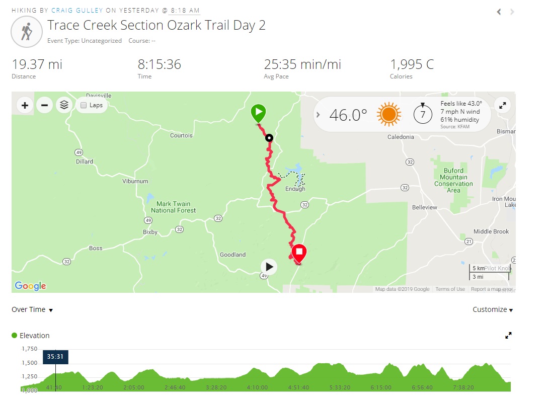
Total time walking 8h 15'
we finished around 4 pm.
Ascent: 2542'
Decent: 2454'
Cory Excellent video of our adventure
Thanks Guys for another great weekend in the woods
No comments:
Post a Comment
Because of spammers, I moderate all messages. Your comments should be posted shortly- Thank you