The end is here. I am melancholy this morning, having had a terrific time and not wanting this Challenge to end. I think, while packing up, just turn around, head back West! I shake off that thought as I want to stay in the moment of today. I may not have stayed to my goal of slowing down and starting later, but I have stayed in the moment each day and that has led to a much more fulfilling mental crossing this year.
I have traditionally finished on a Thursday, not sure why, except when I started, all the Challengers that I sought or discovered advice from, finished on a Thursday. You do have one more day, as the last official finish day is Friday. Next time I think I will take all my days.
It was a wet night and a wet morning as Challengers packed up and prepared for their final walks to the coast. There is a high probability of rain again today so most Challengers have their rain gear on this morning.
We are quite lucky that we all got to stay here. This caravan park was heavily damaged in the same storm that took out the bridge in Edzell (in yesterday's post). Lots of the permanent caravans (mobile homes) were damaged and being repaired while we were here. The owners did a really great job getting the sites ready in time for us to use the facility this year. - Thank you D.C.P.

The Scottish flag flying in the stiff morning breeze. If I had an adopted country, it would be ScotlandLeaving the NWB campsite (It's official name is Dovecot Caravan Park) but since it literally backs up to the North Water Bridge, I think everyone just calls it that.
Passing over the River North Esk for the first of many times today. Today is just a giant road walk for 98% of the day. However I am taking a slightly different route, one I have never taken before. The main road walking route goes almost directly south toward a town called Hillside. I am instead going to turn east toward Marykirk and cross over the North Esk river and then turn south down the river's east side.
I am doing this for two reasons; I have not been this way before, but also I am hoping the road will have less traffic. The main route has been very busy in the past and none of these roads have shoulders. Below- you can tell you are at the eastern side of Scotland when you get the yellow rape seed oil fields. Passed by a cottage in Gallery with a beautiful display of flowers along the house. I think this is wisteria and poppies.
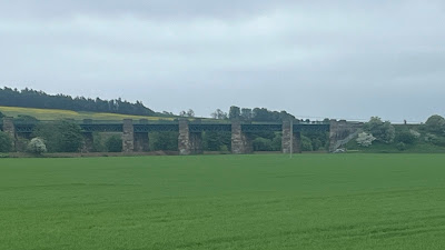
Continuing on, you walk by a magnificent train trestle heading into Marykirk. I have been on this line coming south from Stonehaven, but never noticed this bridge. I have been rewarded so far as this section of road has been very quiet this morning. Crossing over the Marykirk Bridge
The River North Esk is my companion for a second day straight. After crossing over the bridge, I did have to wait a few minutes, for traffic to let up, before I can safely cross. I get on a very lonely road toward the Den of Morphie Bridge.
Lots of farming here.
Potato fields, you can tell by how deep the rows are plowed.
Den of Morphie Bridge
Church of Logie My first view of the sea
The side of the road was filled with wildflowers.
As you go steeply down this road, I was admiring the sea viewThen suddenly you pop out at the monstrously busy A92 with no shoulder and have to cross over to the other side! Large trucks and cars whizzing past at high speed all funneling down to the Lower North Water Bridge (below). Architecturally, a beautiful bridge, but not suitable for pedestrians.
Fortunately you only have to be on the A92 for just a short walk of maybe a quarter of a mile or less. I would like to say that I knew what I was going to do here, but I didn't and was very pleased when I discovered a pedestrian bypass to the road bridge. It was just a short zig-zag up the hill. The bypass gave fantastic and safe views in both directions.
Looking at traffic on the car portion of the bridgeLooking out the other side, the River North Esk reaches the sea.
A closer look at the architecture of the car bridge The final walk into Kinnebar is on a hike/bike path, which I had to myself.
You walk past the Kinnabar Links (links=golf course) and reach a parking lot. You can then turn left to go to the beach or right to go to Charlton Strawberry Farm (yum). I knew many Challengers were convening there first before finishing. At this point it had started to rain again, so I had decided to turn left and go and finish on my own.
This had been a primarily solo crossing so finishing solo seemed appropriate. Cresting the last of the sand dunes by the abandoned bothy it really started to pour down with rain. Not quite the finally I had hoped, but it did seem somehow fitting. Going to the sea to dip my toes in the water, completing a coast to coast walk.
Even in the rain I lingered here for a long while This Challenge had come at a good time for me; changing jobs, moving to a new house, starting a completely new chapter in life back home. A successful crossing helped to center me and remind me I am still capable of taking on and successfully completing challenges. I also thought of friends now gone, both having past or just lost to time. I made a little promise to work harder to be a better friend and do more to take advantage of the opportunities I have available.Soon however I realized how wet I was getting so Nessie and I bid farewell to the sea and turned our attention toward strawberry tarts.
I final nod to the person that makes everything I get to do possible 💕Least you think that the day is over, there is still 3.5+ miles to go! First over to the Strawberry Farm, where it seemed the entire place was taken over by Challengers. As soon as I walked in I spotted Andrew and was able to join his table.
Lindsay and her son along with Sir Dave the Beaver soon arrived. Many plates of food were ordered as well as coffee and cake but it seems all the strawberry tarts were sold out and it would be a considerable wait for the next batch.
What could have happened to cause such a shortage? It was Sabine! It seems she had ordered ever combination of food that can have strawberries on it and caused the strawberry shortage.😲😏
However, soon order was restored to the universe and my strawberry tart arrived. It was as yummy as I had imagined.
Even Sir Dave the Beaver got his share
Well I can tell you that after that little feast it was very difficult to go back out into the rain and put on my wet rain jacket and pants. I did manage it, thankfully most of the heavy rain had stopped.
I walked back along the path toward Montrose. To officially end, you have to present yourself at Challenge Control in the Park Hotel and sign out in the official log book. Challenge Control was a busy place when I arrived, but they still greet you warmly, give you a cup of tea and a biscuit. I could hardly get another thing in my tummy at this point (but I managed)
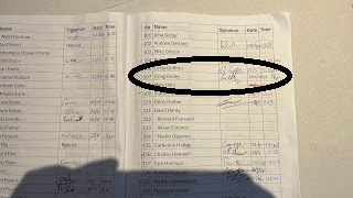
Signing out, 5th crossing done. Today's route, I did stay more inland, on a walking path, after leaving Charlton Strawberry farm. I didn't walk the actual beach this time.
After signing out and collecting my certificate and t-shirt I walked next door to The Link Hotel. This has been our hotel since our first Challenge in 2014 and they have always been very nice to us (Vicky and I) this time was no exception, the room was fantastic.
All the hot water I could want!
A quick walk around the town of Montrose (because I have not walked enough) to pick up a few items I need.
Then toward evening it is back over to the Park Hotel Bar for some drinks and catch up with other Challengers, before dinner. This is the reason I have always finished on a Thursday. You can finish anytime up until Friday, but the biggest post walk dinner celebration has always been on Thursday and it is the best opportunity to see friends that you may not have crossed paths with during the Challenge.
Left to Right ( Laura, Louise, Emma and Kevin that I hung out with in Tarfside)
David on the left, who I spent much time with on the train to Glenfinnan and other places on this Challenge and Jayme Of course Mr Walker (center) who was great to walk with the first day and has been the source of much help over the years.
Dinner was quite good
So was the beer
After dinner there were many speeches, happily brief, but very entertaining. The group of coordinators that look after the Challenge are fantastic and put in countless hours of work to make sure everyone is safe and the event runs smoothly. A couple of them are Ali (standing) and Mick (sitting to her left)
Kevin got a special award given for his 10th Crossing. Legend status achieved, along with standing by Hamish Brown, one of the founders of the TGO Challenge.
It is sad to leave Montrose, but I know the Challenge is not done with me yet. I will return.
The Thanks
“It's a dangerous business, Frodo, going out your door. You step onto the road, and if you don't keep your feet, there's no knowing where you might be swept off to.”- J.R.R.Tolkien
Big thanks to Emma for vetting my route and providing much needed suggestions getting me from the West to the East.
John and Sue, not sure I would have made it those few days if not for your friendship and good cheer.
Andrew for leading the way the first day and always being an excellent roommate.
David for making the train ride go by so fast with great conversation and friendship online and all the way across Scotland.
Ali, Sue, Mick, Gayle for such a great event and a great stay in the hostel.
Everyone at St. Drostan, Tarfside
Louise, just because... you have answers to ever question, and we both love purple.
Jayme, Peter, Kevin, great to see you all again.
Humphrey, a great thanks for befriending me again.
Sabine, Richard, Alex, Stuart, Graham, it was a pleasure to meet you.
All the hotels, hostels and shops that were such a pleasure to use and were a huge help to my crossing, especially the Laggan Coffee Bothy.


