I finally got around to going over to the Daniel Boone Conservation Area, which is only 7 miles from my house. It was one of the first things I planned to do when we bought the new house in Hermann, but it has taken me almost 6 months to actually get over here to see what it has to offer.
There is a large loop trail, on the AllTrails app. It is about 10km (6.7 miles) but as you will see below, it is no longer accurate to follow and the new trail is a bit more, but considerably easier at the end.
The road leading to the conservation area is off Hwy 94 and crosses the Katy Trail. you use Case Rd and then veer left on Tower Rd. I parked at the primitive RV campground area. There we actually 2 cars and a van parked here overnight when I arrived. The temperature this morning was 28F. It was a crisp blue sky day.
I have a habit of taking a picture of where I parked the truck. 😀
I decided to go counter-clockwise. The first bit of trail was just a short road walk on the gravel you can see above to meet the trail. The trail will actually end back at the campground. This is a loop and their are 4-5 places to park that you can pick up the trail.
This section has quite a bit of forestry work and logging going on. Even with the trail being frozen, it was a bit of a mess and I would not want to be through here if it was really wet. The multi-use trail is marked with a purple circle.
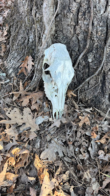
A deer skull This trail actually walks along the ridges. There is not much elevation change, so you do spend about 80% of the trail walking ridge lines, without the leaves on the trees you can get some nice vista views. This is really the first significant elevation coming from the farm/flood plain of the Missouri River.
The only significant elevation change is one dip into a hollow with a creek.
Of course you do have to go back up again. I would suggest this counter-clockwise direction as going up was a much better grade than coming down. This trail is used mostly by horses and the down section was significantly more straight down, rutted and also scared by lots of water run off.
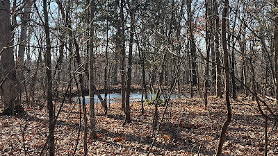
Lots of animal ponds around the entire loop. Perhaps made for the horses A section of young pines
A much larger animal pond that is starting to freeze over, but getting water from here would be easy.
I actually used most of my liter of water on the trail today, much more water than I usually drink for this distance.
(Below) This trail has probably been used by hundreds maybe thousands of horses over the years. they have pounded into very fine soil. 90% of this trail looks like the dirt you see from diggings of feral hogs on the side of most trails. It is soft and wet, so I would not be doing this trail unless it was really dry or like today, a bit frozen. This is the spot where my AllTrails GPS track varied from the actual purple marked trail. I chose to stick with track I had on my phone. The sign says no horses beyond this point, probably should have taken a hint from that. The path that was marked was an excellent old forest road.
Very quickly I find out why no horses. This area has suffered significant blow downs and trail damage, in fact, there is no trail. All I could do is bushwhack following my GPS track here and there around the debris. Looking back up the hill as I followed the "track" down, you can see the blowdowns with not clear path.
It wasn't very long going down the hill but I wished I would have carried on the purple path, but without knowing where that would go, I went with what I had. Once I hit the bottom of the hollow, you can pick up an old path, right on the GPX line. It was faint but there, but clearly nothing has been done down here for a long time.
Contouring along the creek bed, I found the spot to climb back up. The climb out shows years of both water run off and horses making a deep ravine in the path. Not a pleasant few minutes 😉
Once on the top of the ridge again, it was a short walk back to my parking area. As I finished and looked back, I saw a sign saying this section of trail was actually closed for rehab. Obvious given what I just walked through, but no sign exists on the other side to say the same?
I looked at the sign board and nothing more was posted. After I got back, I did grab a paper black and white map that are available almost every conservation area. It does show the re-routed trail (in purple) deviating from the Alltrails GPX track (in Yellow). This purple route was the route I was on until I jumped off at the sign that said "No horses beyond this point"
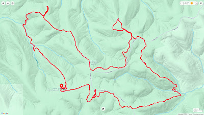
This is the actual GPX track I recorded on my Garmin watch. It shows the little extra lollypop loop I did at the top as well as when I continued on the Purple route and then seeing it had deviated from my GPX track, back tracked and went on the original route (Marked in Blue above = Don't go this way! ) The new official trail ends on Forest Road 1220, not on 1221. It will also make it about .5 mile longer.
Not bad time though for a 10K with a little extra trail miles and some bushwhacking!
I will be back here to do some more training when I don't want to use the big hills around my house 😂


No comments:
Post a Comment
Because of spammers, I moderate all messages. Your comments should be posted shortly- Thank you