The plan is to have me get picked up by the Superior Shuttle Service ( a service I can highly recommend, even if alittle pricey at $40 for a 40 mile trip) and drop me off 60 trail miles at the CR6 trail access point. I will then hike the trail North to South back to the CR301 parking lot. This was so I would not have to worry about getting a cell signal and call them the day before I wanted to be picked up at the 6 parking lot. This turned out to be a good decision as well as walking North to South had a much better flow and more gradual climbs than South to North.
The shuttle was not scheduled to get me until 8:15 am, but I was at the trail head and ready to go at 6:30 am!
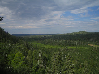
At CR6 you immediately climb to the ridge line and this is the first view I got after only a few minutes of Minnesota woods from the SHT
I am very happy to be here
I will be following the blue blazes on the trees to mark the SHT, and the wild flowers were still in bloom even in July
The Wolf lake area is a wilderness retreat area, with a big lodge on the bluff of the lake. The area has lots of snowmobile and cross country ski trails
In order to keep my pack weight down to a total of 20 lbs with 4.5 days of food and water included. I am only carrying 1 liter of water. This means I need to refill my water about every 4 to 6 miles or so, when its hot. My first stop for water was Kennedy Creek and look at the color of the water AFTER it has been filtered! This turned out to be the clearest of the water I would get
Next up was Tettegouche State Park. This was a beautiful park with a nice suspension bridge over the river and waterfalls.
I took an hour long nap under the bridge and got more water.
This was by far the hardest and toughest day of the trip. I had planned to do 15 miles from CR6 to Bear lake campsite. and I didn't start until I was dropped off at 10:20 am. This a step section leaving the Park below
Mt Trudee is the highest point on this section. It has been 12 miles since my starting point and I still have 3.3 miles to Bear Lake... I am not going to make it! My feet are starting to kill me ( more later) and it is about 4 pm. I think I will look for the next available campsite.
The views from Mt Trudee are spectacular in all directions. It was a great day
I am one whipped puppy
The first available campsite is Palisades Creek, 1.5 miles from Mt Trudee. It is a double campsite ( East and West Palisades Creek). I am wasted, but there is already 12 college kids camped all around. I managed to squeeze in, since I have a small tent and took a 2 hour nap. I didn't even get out of the tent until 7:00pm to make myself dinner.
By the way the water here had the color of beer!
By the way the water here had the color of beer!
Summary for today-
13.5 miles in 7.5 hrs, with 2 major stops, one of about an hour-
1 mile (1/2 mile each way) lost to taking the wrong fork coming out of Tettegouche Park.
Elevation change- Sawmill Dome, Raven Lake, Wolf Lake, Baptism River, Raven Rock, Mt Trudee.
Stung by a wasp on the upper arm 1 mile from the campsite.


No comments:
Post a Comment
Because of spammers, I moderate all messages. Your comments should be posted shortly- Thank you