Day 5 and day 3 in the backcountry. If yesterday was the best day then today was the hardest day. Day 3's are always the hardest days for me mentally. The adrenaline of starting the trip is dying off and generally day 3 is where you start to get into the real "meat" of the backcountry and you think you can up your mileage. Today was no exception with 14.5 miles, 2725 feet of elevation gain and a whopping 5210 feet of elevation loss!
The map below shows we have about half the day on the CDT and then we turn into the interior of the Many Glacier Loop and by all accounts the "really good" scenery should start ???
Leaving 50 Mountain campground this morning you get a glimpse of the ridge we came down from the day before. We came down from the right on the mountain to about half way and then contoured down into the valley and tree line containing the campgound. We could not see any of this yesterday afternoon by the time we reached camp.
Looking toward our direction of travel today
A stone hiker shelter that was started and then abandoned early in its construction.
Despite the reports by the Rangers in our pre-hike briefing about the lack of water, we have founds lots of water and have found it often so far on the hike. Not every source is flowing but many are and the waterfalls and runoffs are spectacular.
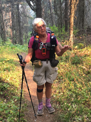
There was more contouring in the morning, but it was all downhill from 50 mountain campsite. You drop from just above the average treeline down into the Waterton Valley watershed. As we walked along we came across Mary Ann Davidson (below) Mary Ann is finishing up her CDT section hike that will make her the oldest person to have hiked all three major long distance trails in the US (PCT, AT and CDT) she didn't start hiking until 61 years old and she is now 76 and going strong. We spent a delightful 30 minutes chatting about the trail, lightweight hiking and life. She is a true inspiration and we enjoyed listening to her stories!
Across a lovely creek with a new bridge and the uphill starts for real.
This creek was to be our companion all the way up the first section of climbing toward Stoney Indian Campsite. The creeks are remarkable clear sprinkled with a fantastic reddish rock. The climb up to SIC was mostly along this stream with an abundance of Huckleberries, Thimble-berries, Raspberries and other edibles.
After Stoney Indian Campsite, where we had lunch, you walk around the lake of the same name and start up the pass
Here you can compare the view from the same place on a clear day
Internet photo
internet photo
Another example of my photo (below)
internet photo
As you descend off the pass into the interior of the Many Glacier Loop you come to an unnamed lake. at the time even in the smoke it looked eerie and amazing
Below is what might have been if it had been clear
internet photo
With a few exceptions after coming over the pass we had 4.5 miles to go to the campsite for the day and it was all downhill. However it was a tough downhill as it was very steep the entire way.
My first real Grizzly experience was with a very large print right next to a stream crossing. it looked very fresh in the mud. In fact we had heard from a couple hikers earlier in the day that they had seen a Grizzly at the top of Stoney Indian Pass
More downhill and more beautiful waterfalls. These waterfalls are Paiota Falls (left) and Atsina Falls (right) That is Wahcheechee Mountain (8419') in the background
Same Spot just wider view
Internet photo
but we should have this....
There is another beautiful falls (Mokowanis Cascades) coming off the back of Atsina Lake
After those falls you reach the Mokowanis Valley floor and the terrain changes back to dense woods and on very flat ground
One more comparison, late in the day, Pyramid Peak is illuminated by the setting sun from our campsite
From the same campsite location even on a stormy day
internet photo
14.5 miles
2725 ' Elevation gain
5210' Elevation loss.


I am surprised at how much water you found! Even with all the smoke, the scenes are exceptional! Without a breeze, that climb, even going down, had to be quite a chore. However, soaking your feet at the end of the day sounded pretty good to me. This has been one of your most interesting and really beautiful hikes. Waiting for more----
ReplyDelete