It has been a nice warm up to this point and my couch to trail strategy has not been as bad on my as I thought it would be. However today things get a bit more serious in terms of distance. 24 miles (38km) and from the looks of things pretty boggy ground for a good portion of it.
I was up really early and made a point to be super quiet so not to wake Sue and John. They had a longish day as well today.
It is a bit of tricky exit from the Bothy area to get going. There is no clearly defined way to head up Glen Sulaig. You know you have to go upstream. A little wooden bridge is your only clue as to how to get going. The picture below is looking back at the Bothy in the cluster of trees.


Starting out, the OS map shows you along what remains of the An t-Suileag, but this just doesn't look right. There was some track here but very quickly it just becomes some tractor tracks in the bog. This has my feet wet and picking my way around the really sinky bits. Will this day be like the last half of yesterday? (yuck)

A closer look at the map (it is early) and I see that the official line has risen 30 meters above me and I have not! I immediately turn and climb up the incline and I find what I am looking for, a path and one that has some solidity to it. My first thought was how do I tell John and Sue to not miss the good path, but they are more experienced than I and probably will not miss it to begin with.

with only a few exceptions this is great walking for the next couple hours. We end at a beautiful sheep farm.


In no time, you reach civilization. paved road, lovely cottages (a couple big houses) and the largest rhododendrons I have seen.


who can ask for a better Sunday morning walk

Finally after a few more miles you arrive at Loy Bridge. this is an aqueduct. The Caledonian Canal flows over the top of you as you walk underneath.
It was about here that I remember what Vanessa Ling, a Challenge legend, mentioned yesterday when we encountered her just outside of Glenfinnan. I had mentioned my route going into Ft William and she had immediately said there as a better way, by going south and then through the forest and finally into Fort William via Gleann Laragain. Feeling my feet now, I would have to say that she was exactly right!

Passing under Loy Bridge.
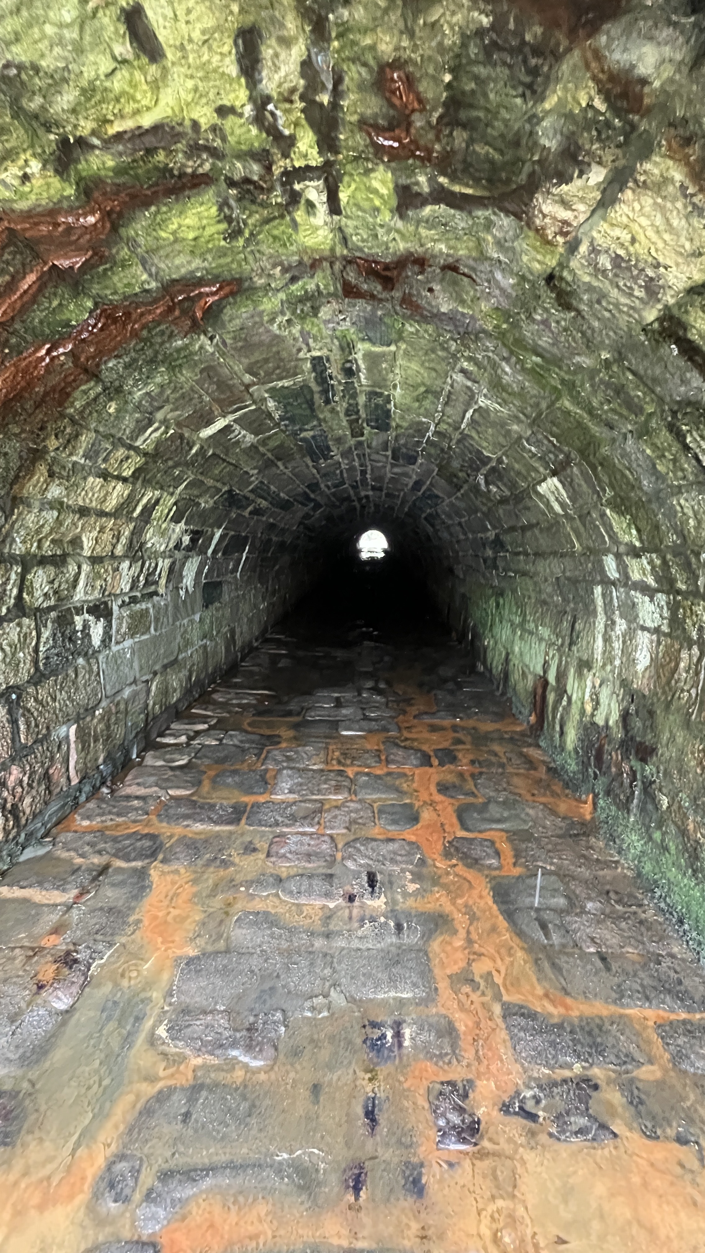

The Caledonian Canal. A big ditch you walk along, but since I have been into watching Narrowboat videos lately, this was actually a bit more exciting...


It is around 3.5 miles (5ish km) of walking to reach Neptune Staircase lochs.


I had planned to walk into Ft William and shop at Morrison's, by the train station, and shop for the next few days as fate would have it, I walked right by a Co-Op, my favorite neighborhood grocery stores.
My pack and I go shopping.


Having no need to go into Ft William proper, after crossing over the River Lochy footbridge, I can cut through some neighborhood streets and cross over the River Nevis on a small footbridge just west of Nevis Bridge and continue on the GGW and Glen Nevis road to the campground


Arriving at the Ben Nevis Campground. This is huge campground with tent sites, hobbit huts and RV sites.

Got a tent spot just under a large tree.

They have a large patio for sitting out and looking at the views of Ben Nevis


While clothes were washing, I could also use a wash. Having only my rain gear to put on afterwards and no towel, I appreciated the hand dryer with an attachment., Everything got blown dry! 😉😆


Later the food "truck" which is permanent opened and the fish and chips was huge and fantastic.


Today's stats, about 24 miles. I included the alternative route that Vanessa mentioned.


It was good to meet you on the Challenge, Craig. Thanks for the credit, but I don't deserve the "legend" title. The route I described is slightly different to the one you drew, in that I dropped down towards Corpach just west of Lochan Kilmallie, hitting the road near Annat Farm, crossed the canal at Corpach Locks and then via Caol to Nevis Bridge. That was because of the lack of tracks down Gleann Laragain. Plus an obsession with canals! I shall now go back to enjoying the rest of your walk! Vanessa
ReplyDeleteThanks for making that clearer for future use, Vanessa and the legend status is well deserved!
Delete