Waking up on Day 8, the weather that has been common on this Challenge has returned. The return of gloomy and overcast with periodic rain and just an overall dampness to the day. After having coffee in the bothy and saying good bye and thanks to Lyndsay, I set off. I had noticed Gordon and Heidi leaving a bit before me, but no one else was really stirring yet. I had no real plans for the day. My itinerary today was to get to White Bridge (another actual bridge) about 15 miles down the Glen, but I figured that I would easily go past that, how far I would get, I did not know.
Immediately upon leaving and taking this first photo, it was obvious, I would be walking the 'wilder' section of Glen Feshie today. From the path and the feeling of the terrain, the normal day walkers and casual visitors to the Bothy would not venture beyond.
Quickly back into more rugged hills
Dipping down for a drink
Several larger river fords that could be by-passed if you watched for re-routes in the track
The clouds and the weather added to the general 'wildness' for the day
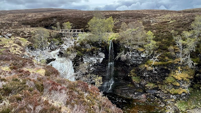
Glad there was a nice bridge to ford this gorge and waterfall. I honestly didn't expect to see something this nice out here today.Gordon crossing the bridge
For about 2.5 miles before the bridge and about 4.5 miles after, the path on the map becomes a single dashed line. A single dashed line on an OS map only means one thing, don't count on a path that is actually on the ground. There might have been a path there at one point (50 years ago) but there won't be one now. The best you can use that single dashed line for is a general direction to walk
the photo above is what is looks like on the ground. Below is an example from my walking map. see the entire 6 km (4.2 mile) distance is covered in 'eye lashes.' This is the symbol for BOGS! and with only a single line on the map, there is virtually no place that might still have rock or other trail material left. If your shoes were dry before now, you can kiss that goodbye !
A lovely little water source streaming off the hills and a good place to stop for lunch with Heidi and Gordon. It was sheltered from the wind, which again had picked up substantially at mid day.
Can you see the remnants of a track?
Above looking across the Geldie Burn to the ruins of the Geldie Lodge and then below a wider view looking back down the burn. (burn = valley with a small river or stream) You come out of the single track and are on 'dry ground' again just past this point. The Mountain Bothy Association (MBA) is building another bothy, similar to Ruigh Aiteachain, called the Red House bothy. It is under construction and will be a fantastic place to stop for the day being about 12 miles from R.A. and very close, coming from Braemar, in the opposite direction
No one can accuse the Red House of not having a fantastic view from the front door! Nearing White Bridge you can see into the southern Cairngorms. The end of the Lairig Ghru path and a few of the higher tops. This would not have been as good a day to be up there as yesterday.
White Bridge - a couple of good camping spots but still lots of day left and a lot of walkers coming up the other way, so just too early to stop. I think it was only around 2:30 pm at this point. River Dee- looking East
A couple miles further on, you come to the ruins of some old Townships. It was threatening rain again so I decided this was a good spot, but to stay out of site, I climbed the hill and had a fantastic view across the Dee to the other side. No one from the path could see me. A bit later on, Gordon pitched his tent right next to the path below me. Lounging in front of my tent, I had the last of some Boursin dip on shortbread. An odd combination but it was delicious and lots of calories!
There is no indication on the map, but I was only about 1 mile from an actual camping area in the trees along the Dee. Oh well, I really liked my view!
Today's Stats:

.JPEG)


For the sake of accuracy, and to give credit to a wonderful charity, it is the MBA (Mountain Bothies Association) renovating the Red House Bothy.
ReplyDeleteThanks Vanessa, I will make that change
Delete